11 best emergency locator beacons
Emergency locator beacons, often referred to as ELTs (Emergency Locator Transmitters), are electronic devices designed to transmit distress signals in the event of an emergency. These beacons are used primarily in aviation, maritime, and outdoor activities to alert search and rescue teams to the location of a distressed vehicle, vessel, or individual. Here's what you need to know about emergency locator beacons:
Purpose: The primary purpose of emergency locator beacons is to facilitate rapid and accurate search and rescue operations by broadcasting a distress signal that can be detected by satellites and ground-based receivers.
Types of Emergency Locator Beacons:
- Emergency Position Indicating Radio Beacons (EPIRBs): Used in maritime applications, EPIRBs are designed to float and activate automatically when submerged in water. They are commonly found on boats and ships.
- Emergency Locator Transmitters (ELTs): ELTs are used in aviation and are typically installed in aircraft.They activate upon impact or manually by the user in the event of an emergency.
- Personal Locator Beacons (PLBs): PLBs are designed for personal use and can be carried by individuals participating in outdoor activities such as hiking, skiing, or boating. They are manually activated by the user.
Activation: ELTs and EPIRBs often have automatic activation mechanisms that trigger the beacon when subjected to specific conditions, such as a crash or submersion in water. PLBs, on the other hand, are manually activated by the user in distress.
Frequencies: Emergency locator beacons transmit distress signals on specific radio frequencies, including 406 MHz for satellite communications and 121.5 MHz for homing by search and rescue aircraft.
Satellite Communication: Emergency locator beacons are equipped with a transmitter that communicates with satellites in orbit, such as the COSPAS-SARSAT satellite system. This communication allows for global coverage, enabling search and rescue teams to locate distress signals regardless of the location.
Identification and Registration: Each beacon is assigned a unique identification number, which is registered with relevant authorities. This registration includes important information about the owner, vehicle or vessel, and emergency contacts.
GPS Integration: Many modern emergency locator beacons are equipped with GPS technology, which allows for more precise location information to be transmitted to search and rescue teams. This feature can significantly reduce response times.
Battery Life: Emergency locator beacons typically have long-lasting batteries to ensure that they remain functional for an extended period. Batteries are periodically checked and replaced as needed.
Regulations: Emergency locator beacons are subject to regulations and standards established by government agencies and international organizations to ensure their reliability and performance.
Search and Rescue Response: When a distress signal is detected, search and rescue teams are dispatched to the location indicated by the beacon. The information provided by the beacon, including GPS coordinates, assists in locating and rescuing individuals or crews in distress.
Emergency locator beacons are critical tools for ensuring the safety and survival of individuals in distress situations, whether they are in the air, at sea, or participating in outdoor activities. Their reliable performance and global coverage make them invaluable for search and rescue operations.
Below you can find our editor's choice of the best emergency locator beacons on the market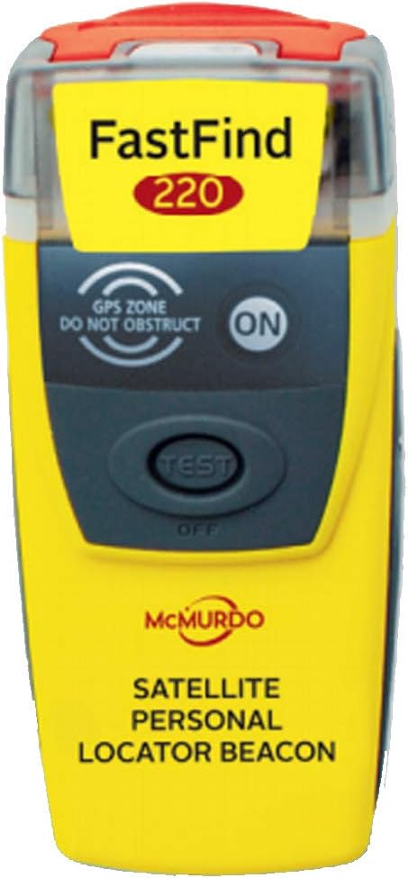
McMurdo FAST FIND 220 Personal Locator Beacon (PLB) (45016)
McMurdo
Product description
A personal location beacon (PLB) is a personal safety device designed to alert search and rescue services and allow them to quickly locate you in the event of an emergency, on land or sea.
- 406/121.5MHz plb
- Easy to operate
- No subscription needed
- High brightness LED SOS light
- Minimum 24hr continuous operation
User questions & answers
| Question: | Is there any service fee or any monthly cost |
| Answer: | There are no monthly fees, you just need to register the device. It is strictly for rescue only--not like some beacons that allow you to send out an I'm OK ping. The battery is supposed to last 6 years. |
| Question: | How easy would it be to accidentally activate the beacon, thanks |
| Answer: | Not very easy. You have to deliberately remove the top first. I have never had a problem in two years. I carry it in my backpack. |
| Question: | how do you make sure the battery doesn’t die while you’re out on a hike |
| Answer: | Do the test function outlined in the owners manual. |
| Question: | It is a one time use? If yes, then after using what do you do with it? Send it back to manufacture or just throw it in the garbage |
| Answer: | I believe you would send it back to the manufacturer for a battery replacement. This service is recommended after about 5 years anyway to ensure you have good batteries. Then it can be used an additional 5 years before it is retired. Hopefully, if you ever need to use the device to summon a rescue, you won't be worried about the cost of a battery replacement. |
| Question: | What is the range |
| Answer: | It works wold wide in any location as it communicates with the satellite. However once it's activated it will be transmitting signal for 24 hours. If you are in a distant location that search and rescue needs more than 24 hours to find you then we recommend getting any of our EPIRBs, GlobalFix V4, Pro, or iPro. They last from 48 to 65 hours. |
| Question: | Once activated, is there any type of confirmation that your signal has been received |
| Answer: | The unit will keep blinking while the signal is been transmitted. There is no return confirmation only sending out. However, you are able to test the unit before going out on a trip by performing a self-test. |
| Question: | how difficult would it be to accidentally activate this device |
| Answer: | I'd say fairly difficult. That yellow flap on the front protects the activation mechanism and the spring is fairly robust. |
| Question: | will it work from inside a car or rv |
| Answer: | Yes. It is a radio frequency- sat freq. may not work inside a cave, deep and narrow canyon, or below a multi-level parking garage. |
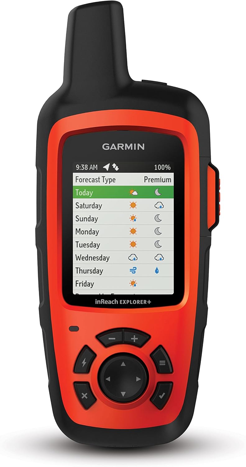
Garmin inReach Explorer+, Handheld Satellite Communicator with Topo Maps and GPS Navigation
Garmin
Product description
You may venture off the grid, but you’re never out of reach as long as you’re carrying an inReach SE+ or inReach Explorer+. These handheld satellite communicators are designed for the outdoor enthusiast who wants to roam farther and experience more without compromising their loved ones‘ peace of mind. From backcountry experiences to international adventures, inReach provides communication, location sharing, navigation and critical SOS functions for anyone who loves getting away from it all, on land, water or in the skies.
- 100 percent global Iridium satellite coverage enables two way text messaging from anywhere (satellite subscription required)
- Trigger an interactive SOS to the 24/7 search and rescue monitoring center
- Track and share your location with family and friends. Water rating : IPX7. Battery : Rechargeable internal lithium ion
- Pair with mobile devices using the free earthmate app for access to downloadable maps, U.S. NOAA charts, color aerial imagery and more
- In reach explorer+ device adds preloaded Delorme topo maps with onscreen GPS routing plus built in digital compass, barometric altimeter and accelerometer
User questions & answers
| Question: | Can this device be used as a gps without an active satellite subscription |
| Answer: | Yes it can. Without a subscription the inReach Explorer+ has a 24k scale topo map of North America built-in and the ability to navigate using its compass, barometric altimiter, and accelerometer. But why would you pay $450 for these features when Garmin and other companies give them to you for much less in other devices. The significant reason to buy the inReach is its satillite communication features, including GEOS Search and Rescue response. Please note, if you don't have an active subscription you CAN'T TURN IN ON from the trail. If you get into an emergency situation you won't have satellite access. Therefor you can't get an SOS through. You can't send an email to DeLorme (now Garmin) to turn it on. You're isolated from the outside world even though the device has the features you need. Without the active subscription they won't work. Because of this, I choose to subscribe to the ANNUAL plan which is always active. The cheapest version is under $15 / month including taxes. That way I'm always assured of communications even if I break down on the Interstate outside of cell phone range. Their other FREEDOM plan is a bit more expensive but allowes you to turn the subscription on or off on a monthly basis. This seems like a great option if you only hike during the Summer months. But don't look to it when you slide off the road in January and you have no active service. |
| Question: | Does it cost when you receive messages or is it included in the plan |
| Answer: | You are charged for messages sent and also messages received. You also pay for tracking points (your location) sent to your online map for friends to follow you. What you are charged depends on the level of service you choose and the subscription plan you have. The basic SAFETY level at $11.95 (Annual Contract plan) or $14.95 (Freedom plan - no contract) each month. It gets you 10 messages and no tracking points. Additional messages are $0.50 each. Tracking points are $0.10 each. The RECREATION level has unlimited messages and tracking points and costs $49.95 or $64.95 each month depending on your plan. |
| Question: | I'm trying to figure out the satellite subscription. does it include any search & rescue insurance? find me spot does, but i don't like their device |
| Answer: | Yes, a subscription to GEOS (the same search and rescue service offered with a SPOT) is included with the monthly fee. |
| Question: | If the Iridium service is suspended, does this device become a paperweight like the Explorer, locking you out of the gps, tracks, msg history, etc |
| Answer: | Iridium is used for two functions, messaging and track updates to your MapShare page. The GPS features are self contained, like other Garmin units. So without the satellites you still have your exact location on a 24k scale map, digital compass, track log on the InReach for easy return via the same route, pre-loaded waypoints and routes for navigation, and the ability to connect to a Smarphone where you may have pre-downloaded additional maps, such as color satellite views. What you lose if satellites are down (which they never are) is connectivity with the outside world through messages and track reporting to your MapShare site. Think of it this way. If you had a GPS app on your phone and the cell service went down you still could see where you are on your app but you couldn't text home. |
Product features
Garmin inReach Explorer+
Handheld Satellite Communicator with Maps and Sensors
Explore Anywhere. Communicate Everywhere.
Using the worldwide coverage of the Iridium satellite network, these go-anywhere portable devices let you exchange text messages with any cell phone number or email address anywhere – while using GPS to track and share your journey’s progress.
In case of an at-risk situation, you can also use inReach to trigger an SOS to the 24/7 monitoring center, text back and forth about the nature of your emergency, and receive confirmation when help is on the way.
Track and Share Your Whereabouts
Turn on the tracking function of your inReach SE+ or Explorer+ communicator, and let family and friends follow your progress on their computers or mobile devices, using the web-based MapShare portal. The inReach device will send waypoints at preselected time intervals, so followers can track your whereabouts online. You can also invite your crew back home to use MapShare to ping your inReach unit and see your GPS location, track your movements and exchange messages during your trip. You can even embed your MapShare page on a blog, website or social media.
Get Weather Wherever
The optional inReach weather forecast service provides detailed updates directly to your inReach device, compatible smartphone or tablet paired with the Earthmate app, so you’ll know what conditions to expect en route. Basic and premium weather packages are offered. And you can request weather forecasts for your current location or any other waypoint or destination on your itinerary.
Who Will Answer Your SOS? GEOS Will.
GEOS is the world leader in emergency response solutions and monitoring. They’ve supported rescues in more than 140 countries, saving many lives in the process. And they’re standing by 24/7/365 to respond to your SOS, track your device and notify the proper contacts and emergency responders in your area. Then, while help is on the way, GEOS will continue to text back and forth with you, providing updates and critical information until your situation is resolved.
Pair with Your Mobile Device
For even more capability and convenience, the free Earthmate app syncs your inReach handheld via Bluetooth with your compatible Apple or Android device so you can access unlimited maps, aerial imagery and U.S. NOAA charts. Plus, Earthmate allows you to conveniently use all of the inReach features on your paired mobile device. For easier messaging, you can also sync your inReach device with your phone’s contact list to reach anyone, anywhere – with fewer keystrokes.
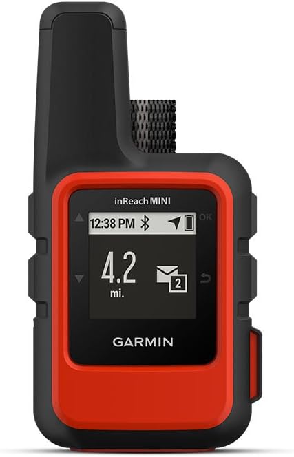
Garmin inReach Mini GPS Satellite Communicator
Garmin
Product description
Garmin inReach Mini GPS Satellite Communicator People who forge their own path need a reliable traveling companion. Meet Garmin’s inReach Mini, a compact, lightweight satellite communicator with GPS. When you go off-the-grid, inReach Mini is your go-to device for maintaining contact anywhere on the planet. This pocket-sized marvel allows you to send and receive text messages, track and share your journey and, if necessary, trigger an SOS alert to contact the GEOS 24/7 emergency response team. No matter where you go, inReach connectivity lets your family and friends stay in touch. Ideal for all athletic training, camping and anytime you want to ensure you won’t be cut off from the rest of the world. Features: Small, rugged, lightweight pocket communicator enables two-way text messaging with 100% global Iridium* satellite coverage (satellite subscription required) Stay safe with the interactive SOS trigger to the 24/7 search and rescue monitoring center (satellite subscription required) Keep in touch by sending and receiving inReach messages through compatible Garmin devices, including connected wearables and handhelds You’ll never be lost with location tracking and sharing; let your family and friends know exactly where you are Pairs with your mobile device for access to downloadable maps, U.S. NOAA charts, color aerial imagery and more using the free Earthmate app with compatible devices Check the weather with the optional inReach weather forecast service that provides detailed updates directly to your inReach Mini or paired device2; basic and premium weather packages av
- Small, rugged, lightweight satellite communicator enables 2 way text messaging using the 100 percentage global Iridium network (satellite subscription required)
- Trigger an interactive SOS to the 24/7 search and rescue monitoring center (satellite subscription required)
- Access downloadable maps, U.S. NOAA charts, color aerial imagery and more by using the free Garmin Earthmate app and compatible devices
- Optional inReach weather forecast service provides detailed updates directly to your inReach Mini or paired device, basic and premium weather packages available
- Send and receive inReach messages through compatible Garmin devices, including connected wearables and handhelds.Display resolution:128 x 128 pixels
- NOTICE: Some jurisdictions regulate or prohibit the use of satellite communications devices. It is the responsibility of the user to know and follow all applicable laws in the jurisdictions where the device is intended to be used
User questions & answers
| Question: | Does the phone you are sending a message to need a special app to receive it? Also, has anyone tried this in the Adirondack Mountains |
| Answer: | All inReach devices have the ability to send a message to someone's email or SMS number. The recipient does not need a special app, just the ability to receive the message and reply. While I have not hiked in the Adirondack Mountains, I know that we have beta testers in that area and can report lots of successful trips in the White Mountains of NH and the mountains of Maine. |
| Question: | How do you send messages? Is there a keyboard |
| Answer: | The inReach Mini doesn't have a virtual keyboard like the inReach Explorer+ but it does have a vertical scrolling list of letters, numbers, and symbols. This is similar to the interface you see on a Garmin wearable like the Fenix and it lets you send a custom message to one of your contacts or reply to an incoming message. You can also select and send one of your Quick Text replies that you modified before leaving on your trip. Selecting the Quick Text "Got your message, will reply when I get to camp." will save you the time to type a message and still let people know you heard from them. There are also Preset messages that are created ahead of time with specific text and specific recipients. Send "I'm checking in, everything is okay!" to your list of friends and family that are following along. Last option, the inReach Mini pairs via Bluetooth with the Earthmate app on your smartphone to let you use the touchscreen keyboard on that device, just like you do with your other texting apps. This is a good option if the weather is nice enough to take your phone out. |
| Question: | How much is the subscription fee to send & receive messages |
| Answer: | Depends on the service, the cheaper plan is $11.95 month for an anual contract or $14.95 / month for the "freedom plan" which you can suspend when you don't use it (for example during winter), although for the freedom plans you will need to pay $25.95 per year to keep the service active. For all intended purposes is like a cellphone plan pre paid or annual contract. More details: https://explore.garmin.com/en-US/inreach/ |
| Question: | What is the tracking points on the monthly plan? Can they be turned off? Also what is the location pings |
| Answer: | There can be same confusion to the terms used to describe features on the InReach. I will try to define each and show its relevance... LOG INTERVAL: This is an internal feature of the InReach that records where you are at repeating intervals of time. You can set the interval. This log is your record of the journey. On the Explorer+ with its internal map these log points will be used to connect a line showing your locations over time as you travel. There is no cost for Log points. TRACKING POINTS: These are a unique and separate set of location recordings that are SENT via satellite and displayed on your MapShare site to let friends and family watch your progress. Since they are transmitted from your InReach in the backcountry via the Iridium satellites they cost you. The subscription plans have options that offer no included tracking points on the lowest cost plan (so you pay 10 cents for each one sent) to unlimited tracking points included with higher priced plans. LOCATION PINGS: A family member ot friend to whom you have given the password for your MapPage site will see a map. If you do not have tracking turned on they can locate your current position by clicking on a LOCATE button. This sends a signal via satellite to your InReach which respons with your location info. It is then displayed on the MapShare map. These location requests cost each time. They are included or not depending on the plan level you are using. WEYPOINTS: These are specific locations that you use to plan a hike. They are not related to your current location but where you would like to be in the future. They are created by you at home on your computer at your unique setup and planning site. So before your trip you create and save a series of weypoints or places that you wish to visit as you travel. Many people will set weypoints for important locations along there expected hike, Such as cross-trail locations, vista overlooks, and resupply locations or overnight huts. Once created they are saved on the Garmin server in your account. When you sync your InReach they are passed and stored within your InReach so they are available off-grid. Weypoints can also be added from the backcountry while hiking. They are available for your navigation on the InReach Explorer+ or on the EarthMate app on your phone connected to any InReach. Newly created weypoints from the trail will automatically be sent FREE to your Garmin account and show on your MapShare site. There is no cost to create and use weypoints. ROUTES: Like weypoints, you may create routes at home from your setup and planning site. On a computer you use a map to define the exact route you wish to follow by clicking on various locations along your intended hike. The system will connect these locations with a line which it calls a route. These routes may be named and saved in your account. Routes may include predefined weypoints but it is not necessary. Routes are synced to your InReach device. They are free. MESSAGES: These are ether text (SMS) or email messages created by you on your trip and sent to anyone. These messages are limited to 160 characters which includes the addresses. Unlike most other satellite message devices, the InReach will also let you receive both text and email messages from anyone. There is a cost for each message sent or received because it uses the Iridium satellites. InReach subscription plans allow a minimum of 10 to an unlimited number of messages each month depending on the plan you choose. So you can control costs, Garmin gives you the ability to limit those who can send you a message by a password to your MapShare site. Any message you send allows for a reply. SOS: This is a special button that you press in a true emergency. It sends your exact location to GEOS, a search and rescue control service. That alone will send help to you. If you are able, GEOS will converse via FREE messages to help your rescue. I hope these definitions help. |
Product features
Fit Global Connectivity Into Your Palm
inReach Mini is your go-to connection for maintaining off-the-grid contact. It’s our palm-sized satellite communicator for adventures where size and weight matter. inReach Mini lets you send and receive text messages, track and share your journey and, if necessary, trigger an SOS alert to contact the GEOS 24/7 emergency response team. With inReach connectivity, your family and friends will know they can stay in touch globally.
Pair with Garmin Pilot
In the aviation world, inReach Mini becomes a valuable air communications link. When paired via Bluetooth to a compatible tablet or smartphone running the Garmin Pilot app, your inReach Mini makes it easy to send and receive text messages while in the cockpit — even from areas without cellular reception. The app pulls in your smart device’s contact lists, so access is simple and seamless. And since your inReach Mini is also a handheld GPS, Garmin Pilot can leverage its rock-solid position source to drive a georeferenced aircraft position symbol on your tablet’s moving map display. Also, for your followers on the ground, inReach Mini can provide tracking of your flight, using the web-based MapShare page created for your inReach account. You can also link via Facebook or Twitter.
Additional Aviation Services
Your inReach Mini is also a supported device for the Lockheed Martin Flight Services (LMFS) Adverse Condition Alerting Service (ACAS), Surveillance-Enhanced Search and Rescue (SE-SAR) and Enhanced Special Reporting Services (eSRS). If you register for ACAS information, alerts provided via LMFS prompt you to call for an abbreviated briefing to address any specific adverse condition situation that might affect your flight-planned routing. Likewise, automatic monitoring provided by the SE-SAR service enables the system to identify potential flight emergency situations and/or signals to promptly initiate search and rescue procedures for your aircraft.
Includes Unlimited Cloud Storage and Trip Planning
Every inReach device comes with free access to the cloud-powered Garmin Explore website to plan your trips with routes and waypoints, create preset messages and quick texts, sync and manage your device settings, update your firmware, link your social media accounts, store all your location tracking data and much more.
Travel Lighter, Communicate Smarter
Measuring just under 4” tall by 2” wide and weighing a mere 4.23 oz, inReach Mini is fit for exterior pack pockets or accessory loops. It connects for messaging via the global Iridium satellite network. You don’t have to worry about being within range of a cell tower or encountering spotty coverage. Your inReach Mini works anywhere.
Who will answer your SOS? GEOS will
GEOS is a world leader in emergency response solutions and monitoring. They’ve supported rescues in more than 140 countries, saving many lives in the process. And they’re standing by 24/7 to respond to your SOS, track your device and notify the proper contacts and emergency responders in your area. Once you’ve triggered a distress signal, you can expect a delivery confirmation that help is on the way and be continually updated on the status of your response team.
Multiple Ways to Connect
Wireless unit-to-unit connectivity lets you remotely control inReach Mini to send and receive messages using compatible Garmin handhelds, wearables or other mobile devices (See Garmin/ble for compatibility). GPS-based location tracking lets you share your whereabouts with those at home or out in the field. You can also post your adventures on social media. For basic navigation, there’s an electronic compass that shows bearing and distance along a route or to a waypoint.
Pair with Your Mobile Device
For even more capability and convenience, the free Earthmate app syncs your inReach handheld via Bluetooth wireless technology with your compatible Apple or Android device so you can access unlimited maps, aerial imagery and U.S. NOAA charts. Plus, Earthmate allows you to conveniently use all of the inReach features on your paired mobile device. For easier messaging, you can also access your phone’s contact list from the Earthmate app to connect with fewer keystrokes.
Get Weather on the Go
The optional inReach weather forecast service provides detailed updates directly to your inReach Mini or compatible device paired with the Earthmate app, so you’ll know what conditions to expect en route. Basic and premium weather packages are offered. And you can request weather forecasts for your current location or any other waypoint or destination on your itinerary.
Rugged, Robust inReach
Tough, durable, impact resistant (MIL-STD-810F) and water-rated to IPX7, inReach Mini is built to keep you up and running. It includes an internal, rechargeable lithium battery for up to 50 hours’ use at the default 10-minute tracking mode and up to 20 days in power saving mode. Battery life may vary, depending on settings. Recharge via the microUSB power cable or optional in-vehicle 12-V charger.
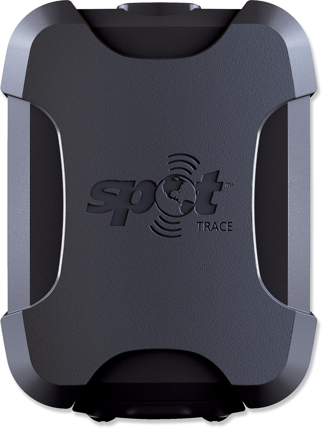
Spot Trace
SPOT LLC
Product description
The SPOT trace offers advanced theft-alert tracking for anything. Instantly receive a text or email when your most valuable assets move anywhere, or follow them on google maps anytime on your phone or computer. Affordable and easy to use, SPOT trace is a no-brainer for your Cars, boats, motorcycles, toys and other valuables. No worries.
- Tracking- view your asset's GPS coordinates online in near real-time
- Movement alerts- receive notifications when SPOT vibration sensor detects your asset has new movement
- Dock mode- configure SPOT Trace to track an asset that is primarily stored on the water
- Low battery & power off messages- receive notifications when SPOT trace's batteries are low or if the device is powered off
- Status message- receive a daily alert to let you know your asset is secure
- Service agreement required.
User questions & answers
| Question: | Could I put this in my yeti cooler or is it not waterproof |
| Answer: | You need a receiver compatible with your provider |
| Question: | If my stolen goods are kept in a home, or multistoried apt. building, will the satellite connection work |
| Answer: | Hello Keith, Yes the Wally will work with this unit! |
| Question: | how long does it hold a charge |
| Answer: | Just to clarify, your question is posted to the KING VQ4550 Tailgater Bundle, which can only be used with DISH. If you are asking about the KING Quest VQ4100, it is compatible with the following DIRECTV receivers: D10, D11, D12; H & HR receivers under 25 (Example: H24)Not compatible with SWM-only receivers (such as models H25 and HR25)If you have any additional questions, please feel free to contact our Service Department at 952-922-6889 x173. |
| Question: | Monitoring cost is reasonable. What is the actual cost of monitoring per device and what are the best companies to approach for this service |
| Answer: | Dear customer, Sorry that this product will not support the original rear camera in cars. You can make an order in the following link. And if you send us your car model, we may be able to provide you some products that designed for the car. This product is an universal model, so it do not have adapters that are different in different cars. Hope it can help you. https://www.amazon.com/dp/B01FM45N50?ref=myi_title_dp |
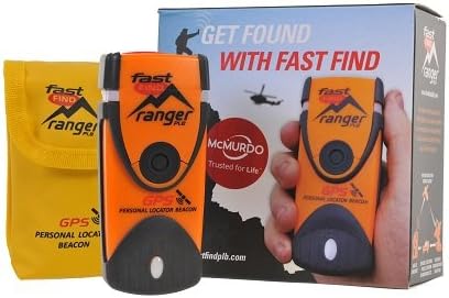
McMurdo Fast Find Ranger PLB - Programmed for US Registration
McMurdo
Product description
The McMurdo FastFind Ranger Personal Locator Beacon (PLB) is a rugged, handheld, and waterproof (non-buoyant) GPS-enabled rescue beacon which is small enough to be easily carried in a back-pack or pocket. Upon initiation of a distress call, the Fast Find Ranger's built-in GPS will fix your position to within a few meters and then utilizes a powerful 406 MHz signal to relay your distress call to orbiting satellites. The Fast Find Ranger is subscription-free and does not rely on commercial call centres, meaning your request for help is received directly by Search and Rescue authorities. When triggered, the Fast Find Ranger broadcasts a unique registered distress signal that not only tells rescuers where you are, but who you are. This is typically within 5 minutes, but can be up to 45 minutes depending on satellite coverage. The Fast Find Ranger features a 121.5 MHz secondary homing transmitter which means that once Search and Rescue teams have been deployed, they are able to home in on your exact location. The unit also features a flashing SOS light which can be used to attract attention. The Fast Find Ranger's lithium power cell offers a minimum 24hr continuous operation and a 6-year battery storage life. Performing a full functional self-test of the PLB's internal circuitry, battery voltage & power and 406 MHz transmission gives you the peace of mind knowing your PLB will work the moment you need it the most. Should you wish to register your device in the US, please choose our ‘Programmed for US Registration’ listing. For registration outside the US please choose our ‘Programmed for Rest of World’ listing and advise us of your required country of registration after purchase so we can program the device for you. Please note that some countries, such as Spain and Germany, do not allow PLB registration unless registered to a vessel. Users in these countries without a vessel can register their devices in the US if required.
- This PLB includes a free reprogramming service which will enable you to register the device in the country of your choice. Should you wish to register the device in the US please purchase our separate listing, ‘McMurdo Fast Find Ranger PLB - Programmed for US Registration’.
- Please note that some countries, such as Belgium, Spain and Germany, may not allow PLB registration but devices can be registered in the US and used anywhere in the world
- Registering your Personal Locator Beacon is required by law in most countries. Registering is very important because should your beacon ever be activated, it is how Search and Rescue Teams will know who you are, and contacts provided may be able to supply information about your specific travel plans. In the absence of this information, it may take longer for a search-and-rescue operation to begin.
- PLBs have been proven, tried and tested in some of the world's most remote locations and treacherous conditions. Even in extreme conditions and situations, the McMurdo Fast Find Ranger PLB activates easily. Just deploy the antenna, pull the anti-tamper seal and press the ON button.
- This PLB should only be used in situations of grave and imminent danger to life. False alerts endanger lives and cause expensive disruption to Search and Rescue services. Deliberate misuse of the device could result in a penalty.
User questions & answers
| Question: | If I register this device in the US, and then go overseas with it, will it work in other countries |
| Answer: | This worked great for me and my wife on the Allure of the Seas! We set up one in our room as a relay and each kept one in our pockets. We could text wherever, and we even bounced messages through 2 nodes once - meaning someone else on the ship was also using them. 10/10 recommend for cruises. |
| Question: | How is this different from the fastfind |
| Answer: | Not sure |

McMurdo FastFind 220 Personal Locator Beacon - US Programming
Product description
The McMurdo FastFind 220 Personal Locator Beacon (PLB) is a rugged, handheld, and waterproof (non-buoyant) GPS-enabled rescue beacon which is small enough to be easily carried in a back-pack or pocket. Upon initiation of a distress call, the FastFind built-in GPS will fix your position to within a few meters and then utilizes a powerful 406 MHz signal to relay your distress call to orbiting satellites.
The FastFind 220's lithium power cell offers a minimum 24hr continuous operation and a 6-year battery storage life. Performing a full functional self-test of the PLB's internal circuitry, battery voltage & power and 406 MHz transmission gives you the peace of mind knowing your PLB will work the moment you need it the most.
The FastFind 220 is subscription-free and does not rely on commercial call centres, meaning your request for help is received directly by Search and Rescue authorities. When triggered, the Fast Find Ranger broadcasts a unique registered distress signal that not only tells rescuers where you are, but who you are. This is typically within 5 minutes, but can be up to 45 minutes depending on satellite coverage. The Fast Find Ranger features a 121.5 MHz secondary homing transmitter which means that once Search and Rescue teams have been deployed, they are able to home in on your exact location. The unit also features a flashing SOS light which can be used to attract attention.
This PLB listing includes a free reprogramming service. Simply contact us after your purchase and we will reprogram the device with your required country code free of charge before shipping to you. If you wish to register in the Rest of World please purchase our separate listing, 'McMurdo Fast Find 220 PLB - Programmed for Rest Of World'.
- This Personal Locator Beacon is pre programmed for registration with the US country code. Whilst it will function anywhere around the world, the initial point of contact during an emergency situation would be the US Search and Rescue authorities with whom the PLB would be registered.
- If you require registration outside of the US, please purchase our alternative listing for 'McMurdo Fast Find 220 PLB - Programmed for Rest of World '. We include at no charge a reprogramming service on this alternative listing to ensure the device can be registered in the country of your choice.
- Registering your Personal Locator Beacon is required by law in most countries. Registering is very important because should your beacon ever be activated, it is how Search and Rescue Teams will know who you are, and contacts provided may be able to supply information about your specific travel plans. In the absence of this information, it may take longer for a search-and-rescue operation to begin.
- PLBs have been proven, tried and tested in some of the world's most remote locations and treacherous conditions. Even in extreme conditions and situations, the FastFind 220 activates easily. Just deploy the antenna, pull the anti-tamper seal and press the ON button.
- This PLB should only be used in situations of grave and imminent danger to life. False alerts endanger lives and cause expensive disruption to Search and Rescue services. Deliberate misuse of the device could result in a penalty.
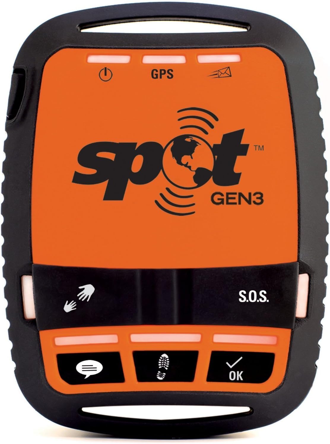
Spot 3 Satellite GPS Messenger - Orange
SPOT LLC
Product description
SPOT Gen3 gives you a critical, life-saving line of communication when you travel beyond the boundaries of cell Service. The latest generation of award-winning SPOT devices, SPOT Gen3 lets family and friends know you're okay, or if the worst should happen, sends emergency responders your GPS location - all with the push of a button. Add this rugged, pocket-sized device to your essential gear and stay connected wherever you roam. Long live adventure. Service agreement required.
- S. O. S. - in an emergency, send an S. O. S. With your GPS location to geos, who facilitates search and rescue
- Check in - let contacts know where you are and that you're okay with a pre-programmed message
- Help/spot S. O. V. - request help from your friends and family at your GPS location. OR, ask for help from professional assistance organizations
- Custom message- let contacts know where you are by sending a pre-programmed message with your GPS location
- Track- automatically send and save your location and allow contacts to track your progress using google maps
- Service agreement required.
User questions & answers
| Question: | how does this gadget let use text around the globe and where is the bill chargeable |
| Answer: | No Smart Phone Required... just a quiet room and Good hearing. |
| Question: | Does the SPOT Gen3 come with the first year Basic subscription($150 first year cost)or is that an additional cost(150unit+150sub=$300 first year cost |
| Answer: | No ,it is use battery ,but RF batteries are not come with , you need another buy 2 pc 1.5V AAA batteries ,available at the 99 cents store . |
| Question: | What is the term of the Basic Tracking Service Plan included with SPOT Gen3? Is it one full year from date of activation or shorter or longer term |
| Answer: | This is hard to answer.It is easy to hear in the same room , but if in the other room I feel like I'm playing cold, warm, hot ...After all, everyone’s hearing ability is different. |
| Question: | How many days do the lithium batteries last when using 10min tracking .. roughly |
| Answer: | no idea, email the company who sold you the product through amazon. they should know something. a |

Spot X 2-Way Satellite Messaging, GPS Tracking SOS Feature w X-HD-X-B
Spot
Product description
2-Way Satellite Messaging GPS Tracking & SOS Feature with GEOS Qwerty Keyboard & BluetoothSPOT X provides 2-way satellite messaging when you’re off the grid or beyond reliable cellular coverage. Connect SPOT X to your smart phone via Bluetooth wireless technology through the SPOT X app to access your contacts and communicate easily with family friends or directly with Search & Rescue services in a life-threatening situation. If preferred or when necessary SPOT X can be used as a standalone communication device. SPOT X has its own dedicated U.S. mobile number so others can message you directly at any time.
Bluetooth:Easily connect the SPOT X device to the SPOT X app and have satellite connectivity at your fingertips.Features:- TRACKING - Choose 2 ½ 5 10 30 or 60 minute tracking intervals and track your adventure with SPOT’s easy-to-use cloud-based mapping
- SHARE - Link your device in SPOT MyAccount to share your adventure
- MESSAGE - Exchange messages with any cell phone number or email address from virtually anywhere in the world
- S.0.S. - Send an S.O.S. to 24/7 Search & Rescue services message back and forth about the nature of your emergency and receive confirmation when help is on the way
- CHECK IN - Quickly and easily let everyone know you’re OK
- COMPASS - Navigate using the built-in compass and programmable waypoints. * on the SPOT X device ONLY not on the SPOT X App
- Height: 6.54"
- Width: 2.9"
- Thickness: 0.94"
- Weight: 7.0oz
- 2.7" Backlit Display
- Impact dust and water resistant (IP67)
- Micro USB port
- Illuminated qwerty keyboard
- Alert 24/7 search & rescue
- Easily connect your smartphone with the SPOT X app
- Rechargeable lithium battery
- 240 hours (10 days) of battery life in 10 minute tracking mode
- Li
- Dimensions: 6.5 x 2.9 x .94in
- Optimal Range: [bluetooth] up to 30ft
- Battery Type: rechargeable lithium
- Battery Life: 240 hours
- Other Features: S.O.S, messaging, bluetooth phone connectivity, app, compass, check-in
User questions & answers
| Question: | Can you message from one spot x to another spot x at base camp? When both are not connected to any cell service |
| Answer: | Yes, so long as both Spot X units have been activated with a separate service plan. Please note that satellite messages can take anywhere from a few seconds to several minutes to send and receive their messages - depending on several factors, the most important being where the overhead satellites are located relative to your location(s) and your Spot X having a clear view of the sky above it. |
| Question: | can you see where someone is without creating a rescue mission |
| Answer: | If the owner/user of the Spot X has provided you with their unique number and you can access the internet, you can see where they are (as of when the Spot X last pinged the satellite with it's location). |
| Question: | I didn’t read anything about being able to make phone calls is that not included with this device |
| Answer: | No, this device does NOT make or receive any type of phone calls, it is strictly used for two-way texting and short SMS messages. If you require actual phone calls, contact any local authorized Globalstar dealer and ask them about their stocking levels of the GSP-1700 satellite phone. I got my sat phone at Off Grid Gear 2 Go in AZ. |
| Question: | does this work for offshore fishing east coast us |
| Answer: | Don't know about east coast. Does work 110 miles off Texas gulf coast. |

OLAS Wearable Mob Crew Tag - 4-Pack
Product description
The ACR OLAS Tag is a Wearable Crew Tracker that integrates OLAS (Overboard Location Alert System) technology. The ACR OLAS mobile application technology detects a break in its "virtual tether" to the tag within 8 seconds of a Tag going missing. The mobile phone(s) then sounds an alarm and records the latitude and longitude of the incident using the phone or tablet's GPS. ACR OLAS then aids the crew with the MOB recovery, clearly directing them to the GPS location where the MOB occurred with clear visual signals and bearing data. ACR OLAS stores all location data and time of incident required by the rescue services. Activate Solo mode on the app (2G phone signal required) when boating alone and the OLAS app will automatically text message (SMS) your emergency contact with your GPS coordinates in the event you get separated from your boat. Users can track up to 6 different OLAS Transmitters with 1 phone/tablet and each individual OLAS Transmitter can be tracked by an unlimited number of phones/tablets. If you want to track more OLAS Transmitters, add the ACR CORE base station or Guardian Engine Kill Switch and scale your system to monitor up to 15 OLAS Transmitters. The ACR OLAS Tag is a compact, "Smart", man overboard system. It can easily attach to adults, children, pets and objects such as overboard floatation devices or Personal Locator Beacons. It is small and portable and can easily be taken from boat to boat to ensure you are always protected. Each tag is supplied with a universal silicone wrist strap with stainless steel buckle and a pre-installed CR2477 Battery (user replaceable). Start small or go big, the ACR OLAS is the only solution that can scale to meet your boating needs. The range of the ACR OLAS transmitters allows for coverage on vessels up to 40 ft in length. However, the transmitter is part of a larger scalable ecosystem of ACR OLAS products (transmitters and receivers) that offer additional safety features and can be combined to track large crews on larger vessels. You can even ditch your phone and utilize your ACR OLAS Tag with the OLAS Guardian Engine Kill Switch or OLAS Core Base Station as part of a more permanent solution.
- ACR OLAS Free Mobile App Integration
- Versatile Attachment Solution (Wrist worn, life jacket, dog collar, attach to Personal Locator Beacon)
- Waterproof (IP 67)
- Bluetooth 4.1 Compatible
- Low Battery Indicator Light
User questions & answers
| Question: | Does the app have to be open & in foreground? Will the alarm sound if the phone is in silent mode, or volume low? Is there an alt. base or just phone |
| Answer: | Yes it does |
| Question: | Will these work even if I lose cell service? When I go 40 miles offshore |
| Answer: | I'm not sure of the exact weight but it is more like 6 pounds. |
| Question: | If the person who has gone overboard is drifting, does their location get updated as they move |
| Answer: | by the look of it , they look like both metric & imperial. it is always handy to have a combination of both as up till about 1972 imperial was used in early aussie cars , also imperial is slightly bigger in their sizes , which means that it fits in the middle of 2 metric sizes. for example 1/2 inch imperial fits in between 12 mm & 13 mm metric , hope this information is helpfull to you both & have a merry christmas and a happy new year. |

ACR HemiLight3 HL3 - Automatic Survivor Locator Light
Product description
The ACR Auto HemiLight3 flashing survival light attaches to almost any style life jacket with the quick and easy installation. Smaller than other approved lights, the HemiLightɜ features rounded edges to maintain the integrity of inflatable life jackets and meets USCG, MED and SOLAS requirements. The high-intensity flashing LED light automatically activates for 20+ hours when it comes in contact with salt or fresh water, and can be deactivated simply by pushing the red button. Attachment loops accommodate up to 5 cm (2 in) wide webbing, and the marine-tough design ensures years of useful service.
- SMALLER OTHER APPROVED LIGHTS
- HIGH-INTENSITY FLASHING LED LIGHT
- 20+ HR WHEN IN CONTACT WITH SALT OR FRESH WATER (automatic activation only)
- EASY DEACTIVATION (PRESS OF A BUTTON)
- QUICK INSTALLATION TO ANY LIFE JACKET
User questions & answers
| Question: | Are batteries replaceable |
| Answer: | Don't know if it is oem but it works good. Does it matter? |
| Question: | Can this light be manually activated |
| Answer: | I would say No, it wouldn’t work for a couple of reasons. The Touch 35 does not have the charging connections on the side like the Montana, and it doesn’t have the locking features on the other side. It also takes less batteries than the Montana. The 35 has a mini USB that you could use for charging, if you wired a USB outlet to your battery. You would obviously need a mount to hold your 35. |
| Question: | What is the installation method for this light |
| Answer: | Yes |

1st Mate Marine Safety and Security System Kit - Mercury SmartCraft Engines - Dual Engines - 8M6007934
1st Mate
Product description
The 1st Mate system is the industry's first engine-integrated intelligent hub and wearable device that integrates with marine propulsion systems to provide safety alerts and information. The main features of 1st Mate include: Man overboard monitoring for captain and up to 7 passengers; distress message capability; and theft deterrent functionality. This kit works with Mercury SmartCraft Engines (dual engines only) and includes the vessel hub, harness & captain fob, an adjustable wristband and carabiner clip. The passenger fobs and wearables are sold separately. The new standard in marine safety and security, 1st Mate adds another layer of boating safety by notifying a boat's captain or its passengers if someone has fallen overboard. 1st Mate also serves as an effective deterrent to boat-and-engine theft.
- Industry's first engine-integrated intelligent hub and wearable device to provide safety alerts and more
- Man overboard monitoring for the captain and up to 7 passengers with wearable fobs
- Distress message capability when overboard for captain and passengers
- Theft Deterrent System allows you to lock your engines to prevent unauthorized use
- Kit includes the vessel hub, harness & captain fob, wristband and carabiner clip
- Works with Mercury SmartCraft Engines (dual engines only)
- Passenger fobs and wearables available (sold separately)
User questions & answers
| Question: | Is it chargeable or battery |
| Answer: | Do not have the hammer here but weight is close to regular claw hammer. Main feature is short handle appropriate for my 6yr. old grandson |
| Question: | Does this light meet the requirements for a visual distress signal |
| Answer: | The Stanley Jr Tool Box Set includes Toolbox, hammer, phillips screwdriver no. 1, phillips screwdriver no. 2, tape measure, and safety goggles. |
| Question: | What type of batteries are used |
| Answer: | Yes, quite a bit of hand tool room. |
| Question: | How do i use velcro strap? lanyard is pretty small -- meant to go around wrist. Not a boater -- for home hurricane kit |
| Answer: | China |
Product features
Emergency Light Signal
On the trail or on the water, the waterproof UST See-Me 1.0 LED Light ensures you can be quickly located in an emergency. An ideal personal locator light, it’s visible for up to 3.4 miles (5.5 km) on a dark, clear night and is great for backpacks, boats, personal floatation devices (PFDs), and more.
Approved by the US Coast Guard (USCG), it provides 20 lumens of 360-degree light, and runs for up to 17 continuous hours on 2 AAA alkaline batteries (not included). It exceeds the USCG visibility requirement of 1 nautical mile of visibility (1.9 km). The lifetime LED bulb never needs to be replaced.
The See-Me 1.0 LED Light has an IPX7 waterproof rating, protecting it against water immersion for 30 minutes at a 1-meter depth. It features easy twist on/off control and it comes with a lanyard cord and hook-and-loop strap. The light measures 4.95 x 1 inches (126 x 25 mm) and weighs 1.8 ounces (51 grams) with batteries. It’s backed by a manufacturer’s limited lifetime warranty.
Secure Attachment
Hook and look strap ensures that the light is tightly secured to your PFD and always within reach
Lifetime of Confidence
Bulb never needs replacing and is ready for any emergency situation
Ease of Use
Simply twist the top of the light to turn on or off
About UST
Ultimate Survival Technologies (UST) has been manufacturing camping, survival, personal safety, and emergency preparedness equipment for over 80 years.
From family camping and ultralight backpacking treks to backcountry rescue and home power outages, UST offers a full range of products for outdoor recreation and survival situations.
Latest Reviews
View allAsus Phablets
- Updated: 14.03.2023
- Read reviews

Foldable Chairs
- Updated: 25.05.2023
- Read reviews

Chromatic Harmonicas
- Updated: 08.07.2023
- Read reviews

Moisturizing Body Creams
- Updated: 27.02.2023
- Read reviews

Portable Indoor Hot Tubs
- Updated: 03.06.2023
- Read reviews